
Brown Trail – Moyar Trail Loop Walk
Starting Point: Picnic Area (Mohercrum). BROWN Waymark Signs.
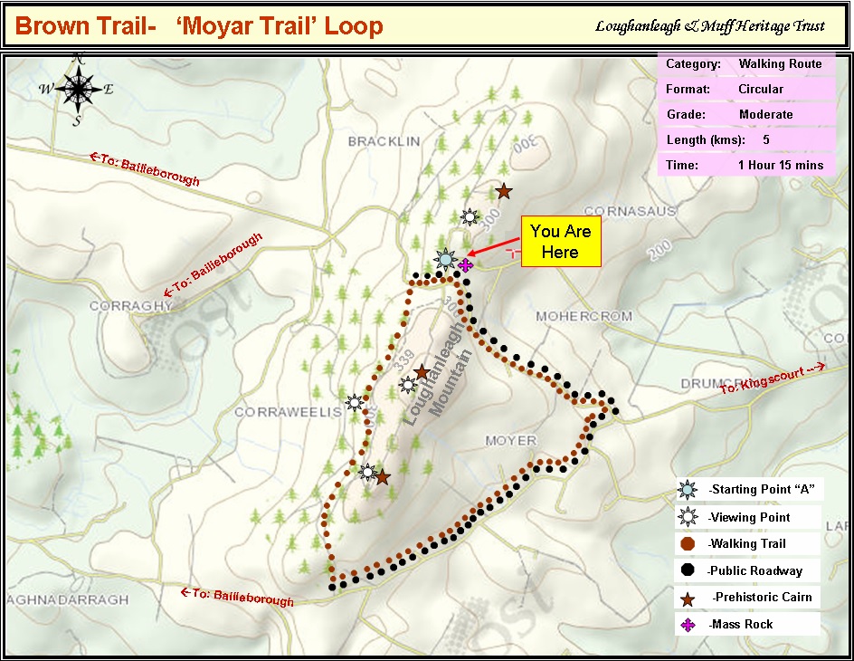
To enlarge map click on image
There is a fairy fort to the right of the mass rock with lovely views at the picnic area .
To access the walking trail, follow the Brown Waymark and ‘Adrian’s Way’ sign 100 metres west (Towards Bailieborough) from the Mass Rock on the main road. Turn left at the trail sign and go through the kissing gate to access the walk through the Coillte forest.
After 600 metres there is a bench on the right with views towards Bailieborough and Cavan Town. On a clear day Cuilcagh Mountain and the windmills in West Cavan are visible. With a height of 665 metres, Cuilcagh is the highest point in both counties of Cavan and Fermanagh and the 165th highest on the island of Ireland. If you proceed a further 600 metres approx. the path enters a forested area. Upon reaching a fork in the path, if you turn left at the viewing point sign this will lead you to a section of ridge offering panoramic views of 13 counties and to the East is the Irish Sea. At this point, if you take the narrow path to your right it will provide access to one of Loughanleagh’s three stone age Cairns.
After rejoining the main path through the forest, continue on the trail until you reach a “T” junction. Follow the brown waymark signs and take the path to your left which will take you down to a picnic table at the end of the trail which adjoins the Kingscourt/Bailieborough Road at the old Edenagully School. Rest for a while here and enjoy the panoramic views of the eastern hinterland of counties East Cavan, Meath, Louth and beyond. At this point on the main road pick up the brown trail sign and turn left and continue on the main road for 1.8km until you reach Moyar Cross T junction. At this point you will see the old King George V post box from the period 1910 -1936. These post boxes are very rare in Ireland. At this junction turn left and continue the last leg of your journey to the picnic area for 1.2 kms approx. The above map outlines the walkway for you. Part of this trail has been developed with the kind permission and co-operation of Coillte.
The map outlines the walkway for you.
Facilities: Picnic Tables; Information panels
Terrain: Mountain & Forest paths and Public Road
Distance: 5km
Grade: Moderate
Approx Time: 1 hr 15mins approx.