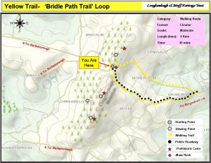
Yellow Trail – Bridle Path Loop Trail
Starting Point: Picnic Area (Mohercrum). Purple Waymark Signs.
 There is a fairy fort to the right of the mass rock with lovely views at the picnic area .
To access this walking trail, turn right and follow the Yellow Waymark signs at the picnic area. After 120 metres turn right and continue on this beautiful old path until you reach the main road. This path derives it’s name from once being the main Bailieborough/Kingscourt access road once used by horses and carriages. The trail boasts panoramic views of the east and the beautiful mountains of the Mourne and Cooley’s and the iconic Sliabh Gullion. During your sojourn you will see remnants of old built heritage along it’s trail and experience the peace and tranquillty of the countyside and nature at it’s best.
After rejoining the main road, turn right (follow the yellow waymark signs) and continue for 2.2kms to loop you back to your starting point at the picnic area.
The map outlines the walkway for you.
Facilities: Picnic Tables; Information panels
Terrain: Old Road Path and Public Road
Distance: 4 km
Grade: Moderate
Approx Time: 45 Mins approx.
